
Tropical Cyclones

Tropical cyclones are powerful weather systems that develop over warm tropical and subtropical oceans. They are associated with extremely low air pressure, meaning that air at the Earth’s surface is rising rather than sinking. As air rises, pressure at the surface decreases, which helps draw in surrounding air and fuels storm development. Tropical cyclones are sometimes referred to as tropical storms, hurricanes, or typhoons depending on where they form, but they are all the same type of atmospheric phenomenon.
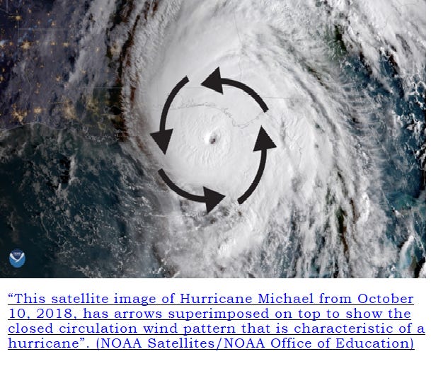
Tropical cyclones gain their energy from warm ocean water, which provides heat and moisture. As the storm strengthens, surface winds begin to rotate around the centre in a continuous circular pattern known as closed circulation. The direction of this rotation depends on the hemisphere: storms rotate anticlockwise in the Northern Hemisphere and clockwise in the Southern Hemisphere due to the Coriolis effect, which is caused by the Earth’s rotation.
As wind speeds increase, a distinct structure begins to form. One of the most recognisable features of a tropical cyclone is the eye, a calm and relatively clear area at the centre of the storm. Surrounding the eye is the eyewall, a ring of towering cumulonimbus clouds where the strongest winds, heaviest rainfall, and most intense weather conditions are found.
How do tropical cyclones form?
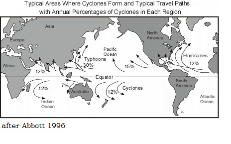
Tropical cyclones typically form between 5° and 30° north and south of the Equator. They cannot form directly over the Equator because the Coriolis effect is too weak to cause rotation. One of the most important conditions for cyclone formation is warm sea surface temperatures of at least 26.5°C, extending to a depth of around 50–60 metres.
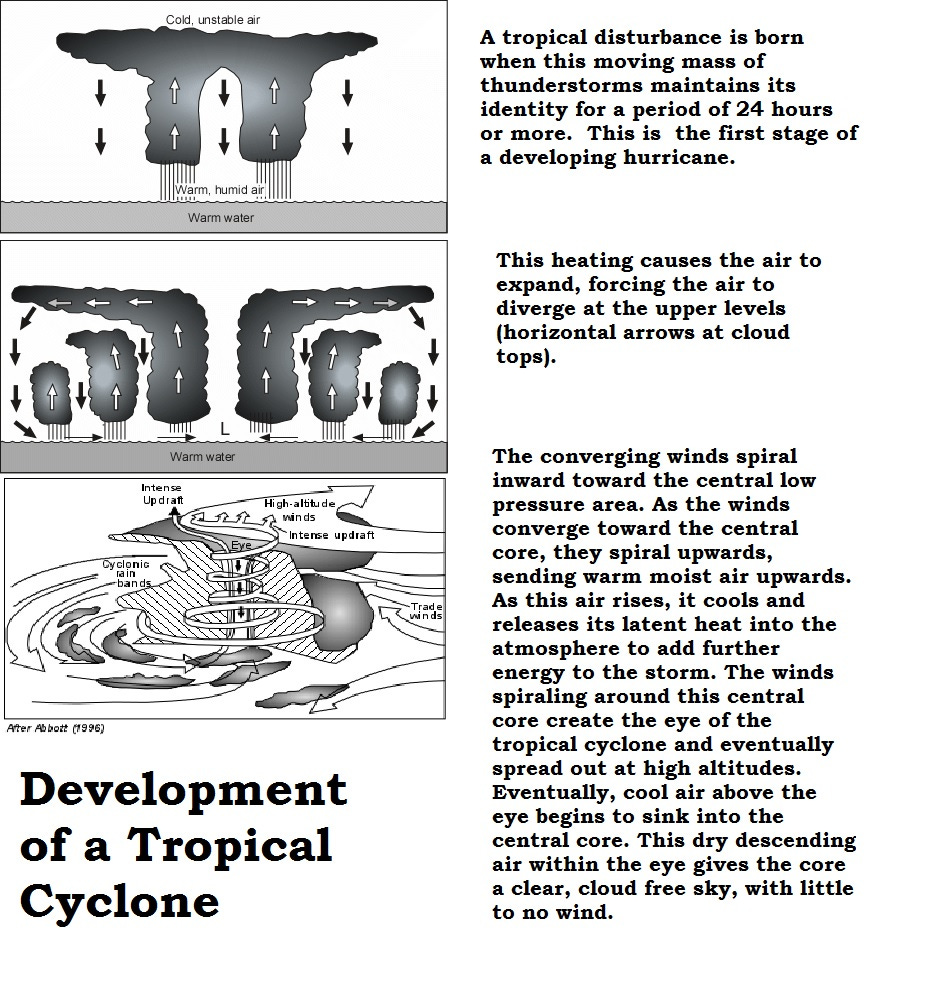
When the sun heats the ocean, the air above the warm water also heats up and becomes less dense. This warm, moist air rises, creating an area of low pressure at the surface. As the air rises, it cools and condenses to form clouds and heavy rainfall. Condensation releases latent heat, which provides additional energy to the storm and causes further uplift. This positive feedback process allows the storm to intensify.
Air from surrounding areas is drawn in to replace the rising air. Because of the Earth’s rotation, this incoming air begins to spiral, forming the rotating wind pattern characteristic of tropical cyclones. As long as the storm remains over warm water and vertical wind shear is low, it can continue to strengthen. Once the system moves over land or cooler water, it loses its energy source and quickly weakens.
For a tropical disturbance to develop into a tropical cyclone, several key conditions must be met:
Warm ocean water of at least 27°C
An unstable atmosphere where temperature decreases rapidly with height
High levels of moisture in the mid-troposphere
Sufficient distance from the Equator to allow rotation (usually at least 200–300 km)
Low vertical wind shear, meaning little change in wind speed or direction with height
Together, these conditions allow a warm-core, non-frontal cyclone with deep convection and a closed surface wind circulation to develop.
Structure of a tropical cyclone
A fully developed tropical cyclone has a well-defined structure. At the centre is the eye, typically 30–50 km wide. The eye is an area of descending air, light winds, and relatively clear skies. Despite the extreme weather surrounding it, conditions in the eye can be calm.
Encircling the eye is the eyewall, which contains the most intense weather. Here, warm, moist air rises rapidly, forming tall cumulonimbus clouds. Wind speeds around the eyewall can exceed 160 km/h in stronger storms, and rainfall rates are extremely high. Spiral rainbands extend outward from the eyewall and can bring heavy rain and strong gusts far from the storm centre.
Classification of tropical cyclones
Tropical cyclones are classified according to their maximum sustained wind speeds:
Tropical depression: winds below 39 mph (63 km/h)
Tropical storm: winds between 39–73 mph (63–118 km/h)
Hurricane / Typhoon: winds of 74 mph (119 km/h) or higher
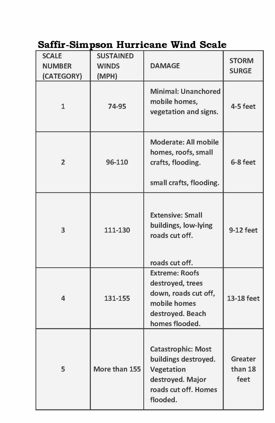
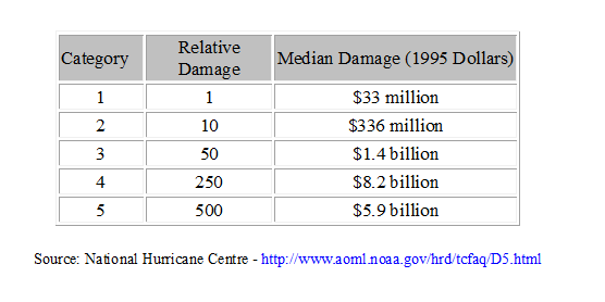
Hurricanes are further divided into five categories using the Saffir–Simpson Hurricane Wind Scale. Category 3–5 storms are known as major hurricanes and have wind speeds of at least 111 mph (178 km/h). While wind speed is important, it is not the only factor determining damage. Rainfall, storm surge, and the vulnerability of affected areas all influence the overall impact.
Naming tropical cyclones
The terms hurricane, typhoon, and cyclone all describe the same type of storm but are used in different regions:
Hurricanes: Atlantic Ocean and eastern Pacific
Typhoons: Western Pacific
Cyclones: Indian Ocean and parts of Southeast Asia
Once a storm reaches tropical storm strength, it is given a name chosen by the World Meteorological Organisation (WMO). Names are reused every six years, but particularly destructive or deadly storms have their names retired to avoid confusion and out of respect for victims.
Hazards associated with tropical cyclones
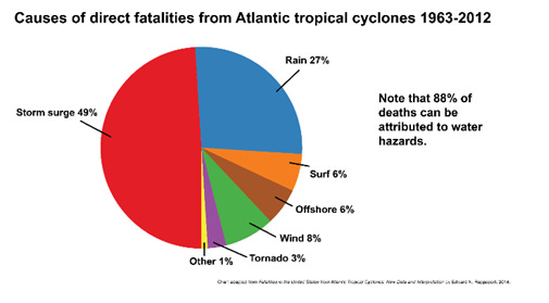
Tropical cyclones pose several serious hazards, including strong winds, heavy rainfall, storm surge, tornadoes, and coastal flooding. Although high winds receive the most attention, water-related hazards are the leading cause of death.
Extreme rainfall and flooding
Warm air can hold large amounts of moisture, and tropical cyclones contain exceptionally warm, humid air. As this air rises and cools, it produces intense rainfall that can last for several days. Flooding often occurs far inland, long after the storm has made landfall, particularly in river basins and low-lying areas.
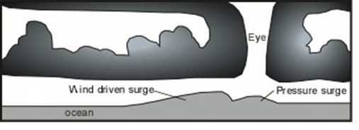
Storm surge – the greatest threat
Storm surge is the abnormal rise in sea level caused by strong onshore winds pushing water towards the coast. This can lead to rapid and severe coastal flooding. Even relatively weak tropical storms can produce dangerous storm surges, and the size of the surge does not always match the storm’s wind category.
Just 15 cm of fast-moving water can knock over an adult, while 60 cm can carry away vehicles. Category 5 storms can generate storm surges over 6 metres high. The highest recorded storm surge, approximately 12.8 metres, occurred in Australia in 1899.
Predicting tropical cyclones
Modern forecasting relies on advanced global weather models such as the ECMWF, GFS, and UK Met Office models. These models analyse atmospheric conditions, sea surface temperatures, and wind patterns to predict storm formation, intensity, and track. While track forecasts have improved significantly, predicting changes in storm intensity remains more challenging.
Reducing the impacts of tropical cyclones
There are several strategies for reducing loss of life and damage:
Forecasting and warnings: Improved satellite monitoring and modelling allow earlier warnings and evacuations
Coastal management: Maintaining beaches, dunes, and wetlands helps absorb storm surge energy
Engineering solutions: Sea walls, flood barriers, and surge gates can protect vulnerable cities
Building regulations: Stronger building codes reduce wind and flood damage
Land-use planning: Limiting development in high-risk coastal areas reduces exposure
Evacuation remains the most effective way to protect human life, especially in low-lying coastal regions.
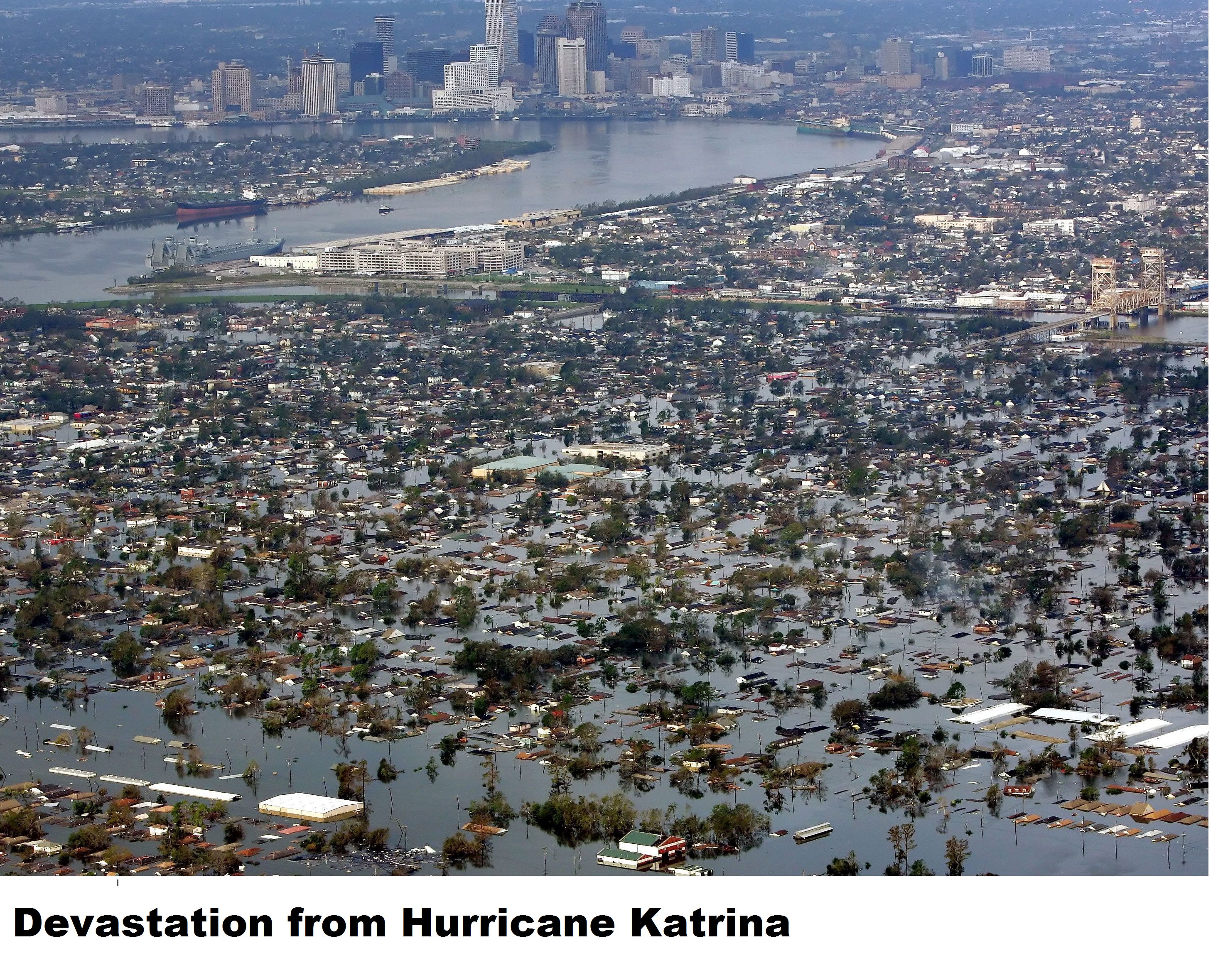
Case study: Hurricane Katrina (2005)
Hurricane Katrina was one of the most destructive tropical cyclones in U.S. history. It caused over 1,800 deaths and approximately $125 billion in damage, primarily in New Orleans and surrounding areas. Katrina reached Category 5 strength over the Gulf of Mexico before weakening to Category 3 at landfall.
The majority of deaths were caused by flooding following the failure of levees designed to protect New Orleans. Around 80% of the city was flooded, leaving thousands stranded without access to food, clean water, or medical care. Investigations later identified serious design and maintenance failures in the flood defence system.
Katrina highlighted the importance of effective disaster planning, reliable infrastructure, and clear communication between authorities and the public.
Tropical cyclones and climate change
According to the IPCC Sixth Assessment Report (AR6), human-induced climate change is already influencing tropical cyclones. While the total number of storms globally may not increase significantly, several key changes are expected:
Sea-level rise is very likely to increase coastal flooding during storms
Tropical cyclone rainfall rates are likely to increase by around 10–15% for every 2°C of global warming
The proportion of very intense (Category 4 and 5) storms is likely to increase
Storms may intensify more rapidly, reducing preparation time
Overall, climate change is expected to make tropical cyclones more dangerous due to heavier rainfall, higher storm surges, and stronger peak intensities, even if storm frequency remains similar.
Key Terms to Learn (and Use in Exams)
Tropical cyclone – A rotating, low-pressure storm system forming over warm tropical oceans
Low pressure – An area where air is rising, leading to cloud formation and rainfall
Latent heat – Heat released when water vapour condenses, powering tropical cyclones
Coriolis effect – The deflection of winds due to Earth’s rotation
Closed circulation – Continuous circular wind flow around a storm centre
Eye – Calm, clear centre of a tropical cyclone with descending air
Eyewall – Ring of intense thunderstorms surrounding the eye
Storm surge – Abnormal rise in sea level caused by cyclone winds
Vertical wind shear – Change in wind speed or direction with height
Saffir–Simpson Scale – Classification system based on maximum sustained wind speed
Rapid intensification – A sudden increase in cyclone wind speed over a short time
Mitigation – Long-term actions to reduce hazard risk
Adaptation – Adjustments to reduce vulnerability to hazards
Resilience – Ability of a community to recover after a hazard event
Short-Answer Questions (2–4 marks)
Define the term tropical cyclone. (2 marks)
State two atmospheric conditions required for tropical cyclone formation. (2 marks)
Explain why tropical cyclones do not form at the Equator. (3 marks)
Describe the role of latent heat in the development of tropical cyclones. (4 marks)
Outline two hazards caused by tropical cyclones other than strong winds. (4 marks)
Data Response / Application Questions (4–6 marks)
Using a labelled diagram, describe the structure of a tropical cyclone. (4 marks)
Explain how storm surge is generated during a tropical cyclone. (6 marks)
Study the Saffir–Simpson Hurricane Wind Scale. Explain why wind speed alone does not fully represent the level of risk posed by tropical cyclones. (6 marks)
Structured Questions (6–9 marks)
Explain the physical processes involved in the formation of a tropical cyclone. (6 marks)
Assess how far modern forecasting has reduced the impacts of tropical cyclones. (9 marks)
Explain why water-related hazards are often more dangerous than wind during tropical cyclones. (6 marks)
Extended Essay Questions (12–20 marks)
“The primary cause of damage from tropical cyclones is storm surge.”
Assess the validity of this statement. (12 marks)To what extent do social and economic factors influence the impacts of tropical cyclones? (20 marks)
“Climate change will increase the risk from tropical cyclones in the future.”
Discuss this view. (20 marks)Evaluate the effectiveness of strategies used to reduce the impacts of tropical cyclones.
You should refer to at least one named case study. (20 marks)
Case Study–Focused Questions
Describe the causes of flooding during Hurricane Katrina (2005). (6 marks)
Assess the role of governance and infrastructure in shaping the impacts of a named tropical cyclone. (12 marks)
Compare the impacts of a tropical cyclone in a developed country and a developing country. (20 marks)
Synoptic / Stretch & Challenge
Examine the links between climate change, sea-level rise, and future tropical cyclone risk. (20 marks)
“Increasing resilience is more effective than preventing exposure to tropical cyclone hazards.”
Evaluate this statement. (20 marks)
REFERENCES
Tropical Cyclones: Observations and Basic Processes — a detailed, modern textbook covering structure, formation, and intensification (Roger K. Smith & Michael T. Montgomery)
FEEL FREE TO BUY ME A COFFEE IF YOU LIKE MY FREE RESOURCES
or one of my inexpensive books at
Ritchie’s Books
Physical Geography
The Atmosphere and Climate Change
If you would like to support my resources scan the QR code below and Buy me a Coffee