
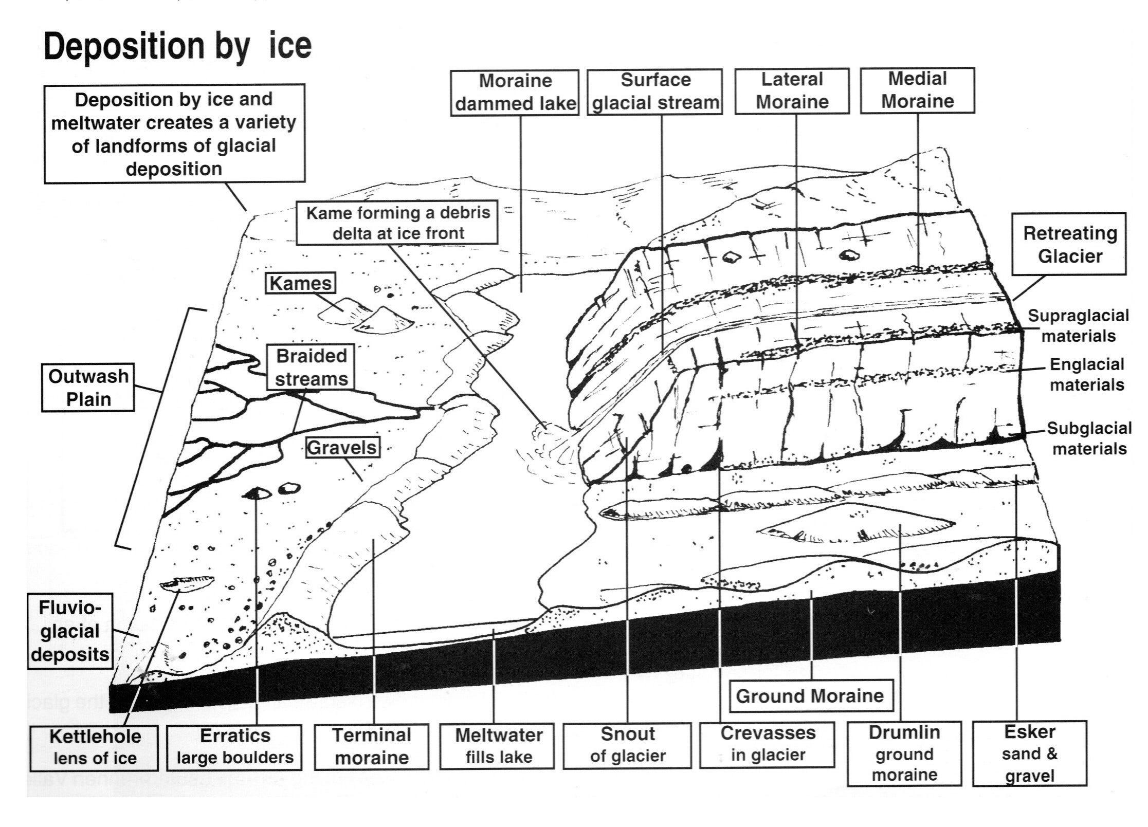
Glacial Deposition

Glaciation shaped much more than the obvious high mountains and their rugged uplands. As ice sheets and valley glaciers grew and moved, they also affected great valleys and lowland plains around their margins. These lower regions often preserve a “record” of the ice in the form of distinct deposition features—landforms and sediment types that show what the ice carried, how it moved, and how it melted.
How glaciers move and deposit material
Glaciers are incredibly effective “transport machines.” They can carry huge quantities of rock debris—ranging from boulders the size of cars to fine clay. The key idea is that debris moves in three different positions relative to the ice:
Subglacial debris
This is material carried under the glacier. It may be moved by the ice itself (forming ground moraine/till) or it may be moved by meltwater streams flowing beneath the ice, which can later deposit it as more sorted material.Englacial debris
Material carried within the glacier. Think of debris embedded in the ice like pieces trapped in a frozen river. When the ice melts, that material is released.Supraglacial debris
Debris carried on the glacier surface. This commonly happens when rocks fall onto the ice (from valley walls or from freeze–thaw weathering) and then get transported until melting releases them.
“Drift” = all glacier-deposited material
The collective name for the material deposited by glaciers—whether boulders, sand, gravel, clay, or mixed sediment—is called drift. Drift includes both ice-deposited sediments and meltwater (water)-deposited sediments, which look very different in the field.
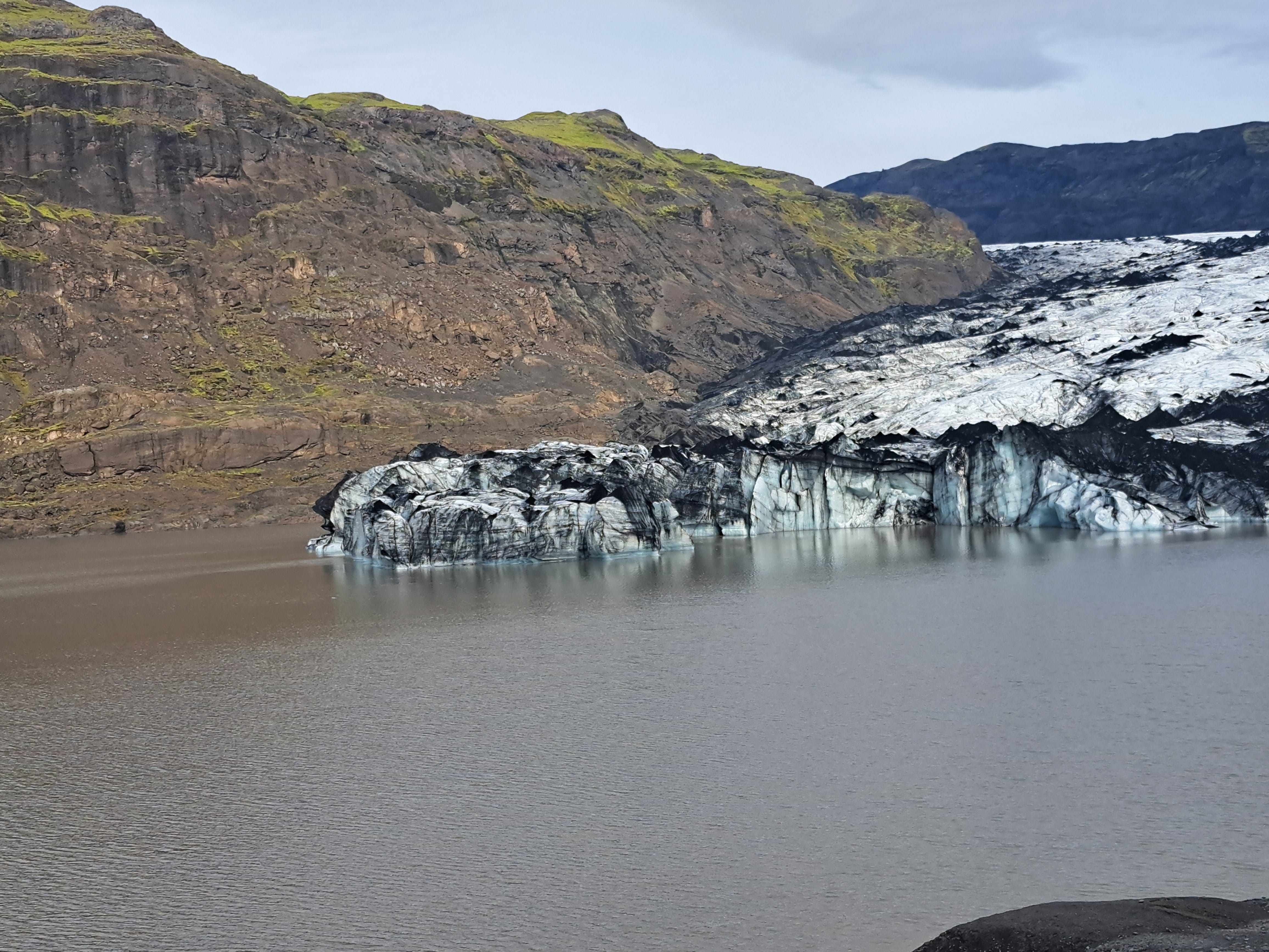
Solheimajokull Glacier (Iceland) and lagoon
Classifying drift: till and fluvioglacial deposits
1) Ice-deposited materials (glacial drift)
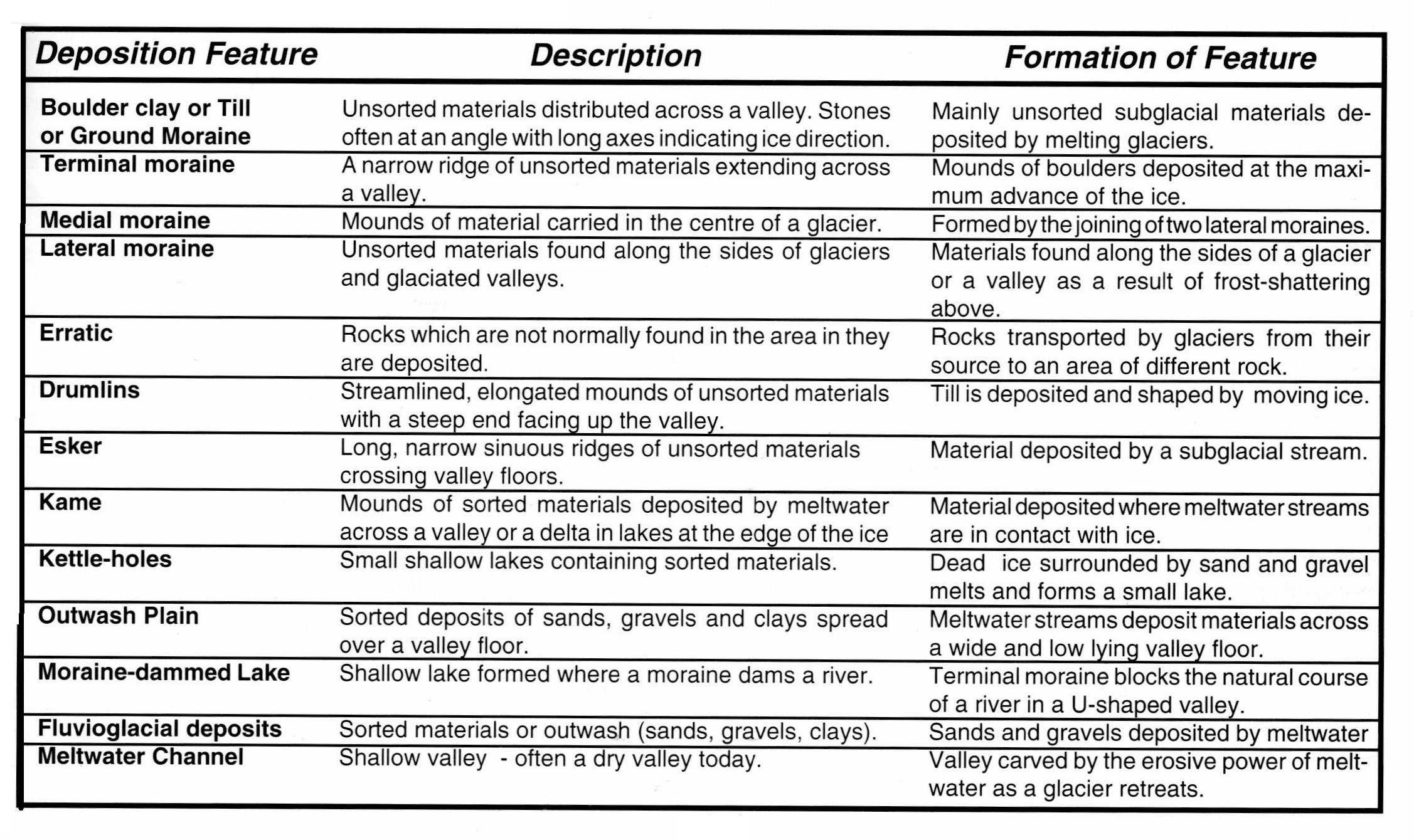
Ice deposits are dominated by moraine material, most commonly till. Till is typically unsorted, meaning you can find a mixture of grain sizes together—large stones mixed with clay.
Ground moraine (or till): unsorted material deposited directly by ice
Till types (subdivisions):
Lodgement till: material pressed and dropped by active, moving glaciers
Ablation till: material dropped when stagnant or retreating ice melts and releases debris
2) Water-deposited materials (fluvioglacial drift)
Meltwater can carry debris away from the glacier, especially from the snout during warmer periods or active melting. These sediments are sorted because flowing water acts like a “sieving” system:
heavier debris (gravels and coarse sand) settles first (nearer the start or faster flow areas)
lighter debris (fine sand, silts, and clays) settles later (further away or during calmer phases)
So fluvioglacial deposits are often layered and more “orderly” than till.
Why are glacial landscapes so complex
Glacial deposition produces complex landscapes because glaciers rarely retreat in a simple straight line. During Earth’s history there were many cycles of glaciation—often discussed as numerous Ice Ages—meaning:
glaciers melt and deposit material,
then later the ice advances again,
and that new ice can rework and override earlier deposits.
As a result, you may see older landforms partially buried, reshaped, or bulldozed into new patterns. In some places, the present-day terrain is therefore a mosaic of different glacial phases rather than a single depositional event.
Two main processes of glacial deposition
A) Direct dumping from melting ice (forming till / ground moraine)
As ice melts, debris carried in, on, or near the surface can be dumped onto the land. Because it is released by meltwater-free ice melting, the material remains unsorted, with all grain sizes mixed.
Ground moraine (till) often shows clues to the direction of ice flow:
If elongated boulders (or rock fragments) are preserved, their long axes often align roughly with the direction the ice moved.
This makes till important evidence: it’s not just material—it’s a “map” of movement.
B) Deposition by meltwater streams (forming sorted outwash)
When meltwater streams flow from the glacier, they carry away debris and deposit it downstream—especially across the floor of U-shaped valleys or in front of retreating ice.
Because water sorts particles by size and weight, deposits become:
layered
graded (coarse at the bottom, finer on top in many cases)
more uniform in texture than till
Glacial vs fluvioglacial landforms can therefore often be distinguished by whether the sediments are mainly unsorted (ice) or sorted (water).
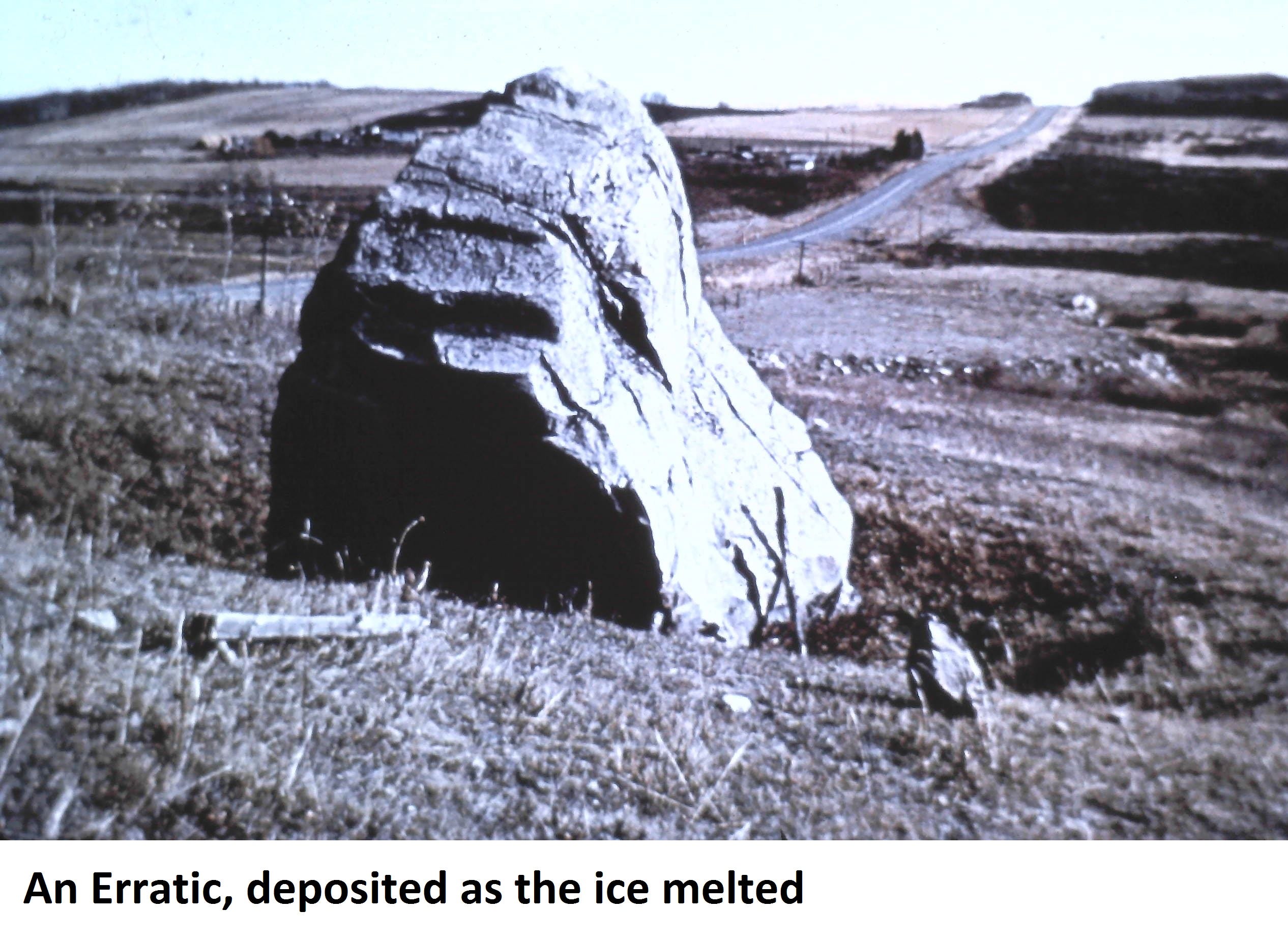
Erratics: travelling boulders that don’t “belong” locally
One of the most striking glacial deposition features is an erratic—a large boulder transported by ice, often many kilometres. A key giveaway is that an erratic’s rock type often differs from the local bedrock:
the boulder’s “source” region was under the moving ice
but the boulder is left stranded far from where it naturally formed
Erratics are dramatic because they demonstrate ice transport clearly: the landscape is showing the glacier’s journey.
Moraines (ice-deposited landforms)
Moraines are ridges or mounds of unsorted material deposited by melting glaciers. Three major types are commonly described:
1) Terminal (end) moraine
Often forms a high, narrow mound extending across a valley floor.
It is deposited at right angles to the direction of ice movement.
It marks the maximum extent of the ice advance.
Typically, the slope facing the ice (ice-contact slope) is steeper than the slope facing down the valley.

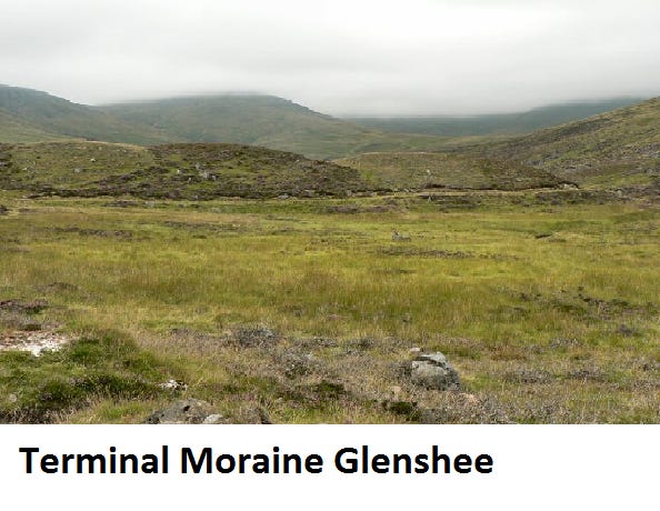
Example : Cromer Ridge.
2) Lateral moraine
Debris deposited along the sides of a glaciated valley.
Often appears as embankments or hummocky ridges.
These form where material accumulated at valley margins—commonly debris incorporated into the ice near the walls and then released as the glacier thinned.
3) Medial moraine
Usually found down the centre of a valley.
Formed when two glaciers (or two ice streams) meet and their lateral moraines merge.
Drumlins: streamlined hills shaped by moving ice
Drumlins are smooth, elongated mounds made mainly of till (unsorted material). They are special because they were not just deposited—they were shaped while the ice was still moving.
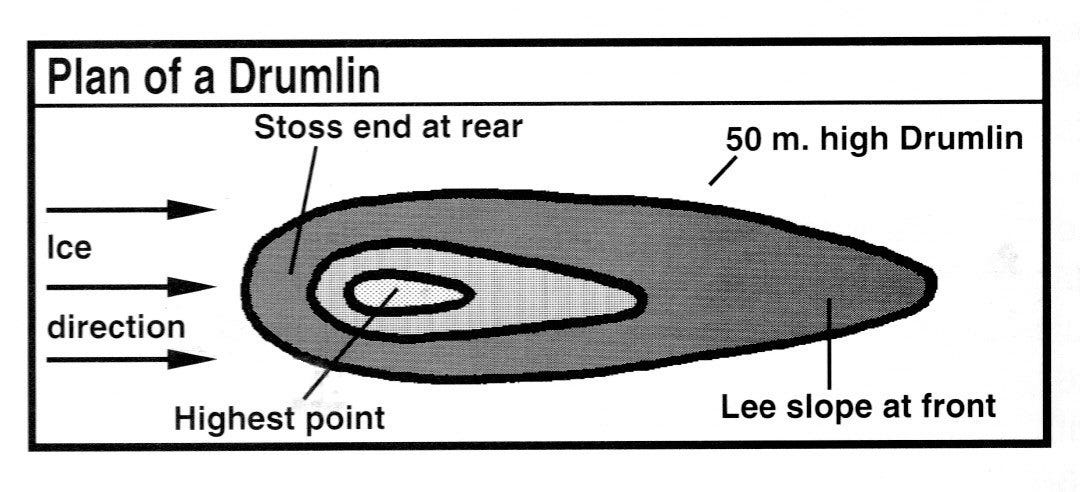
The long axis of a drumlin runs parallel to ice flow.
They form due to the interaction between moving ice and the bed (including pressure, friction, and the “plating” of the ice’s load onto the landscape).
Drumlins can be very large—often tens of metres high and over a kilometre long.
They often occur in groups called swarms, sometimes compared to a “basket of eggs” landscape.
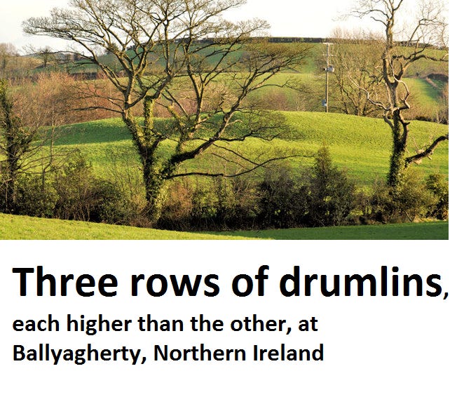
Example : Ribble Valley, the city of Glasgow
Drumlin terrains often have stony, heavy soils (from till), yet in some regions they still support major farming because of how soils weather and develop.
Fluvioglacial features: deposits made by meltwater
Outwash plains (sandur)
Outwash plains are made of gravel, sand, and sometimes clay—laid down by meltwater streams draining from a melting glacier.
Often deposited on top of older till as the glacier retreats.
Can be very thick, up to around tens of metres in some cases.
Meltwater intensity increases during warmer periods, allowing high-energy streams to transport large loads of loose debris.
As water flow slows, sediment drops out and deposits spread across the plain.
Because meltwater can also erode, outwash regions may include both erosional landforms and depositional features.
Varves (annual sediment layers)
A varve is a pair of layers of sediment deposited yearly in lakes close to the glacier:
in colder conditions / autumn: finer silt is deposited
in warmer conditions / spring: more active meltwater deposits coarser sand
So each repeated pair represents one year. Importantly, the thickness changes from year to year can reflect climate variation, letting scientists interpret warmer/cooler periods.
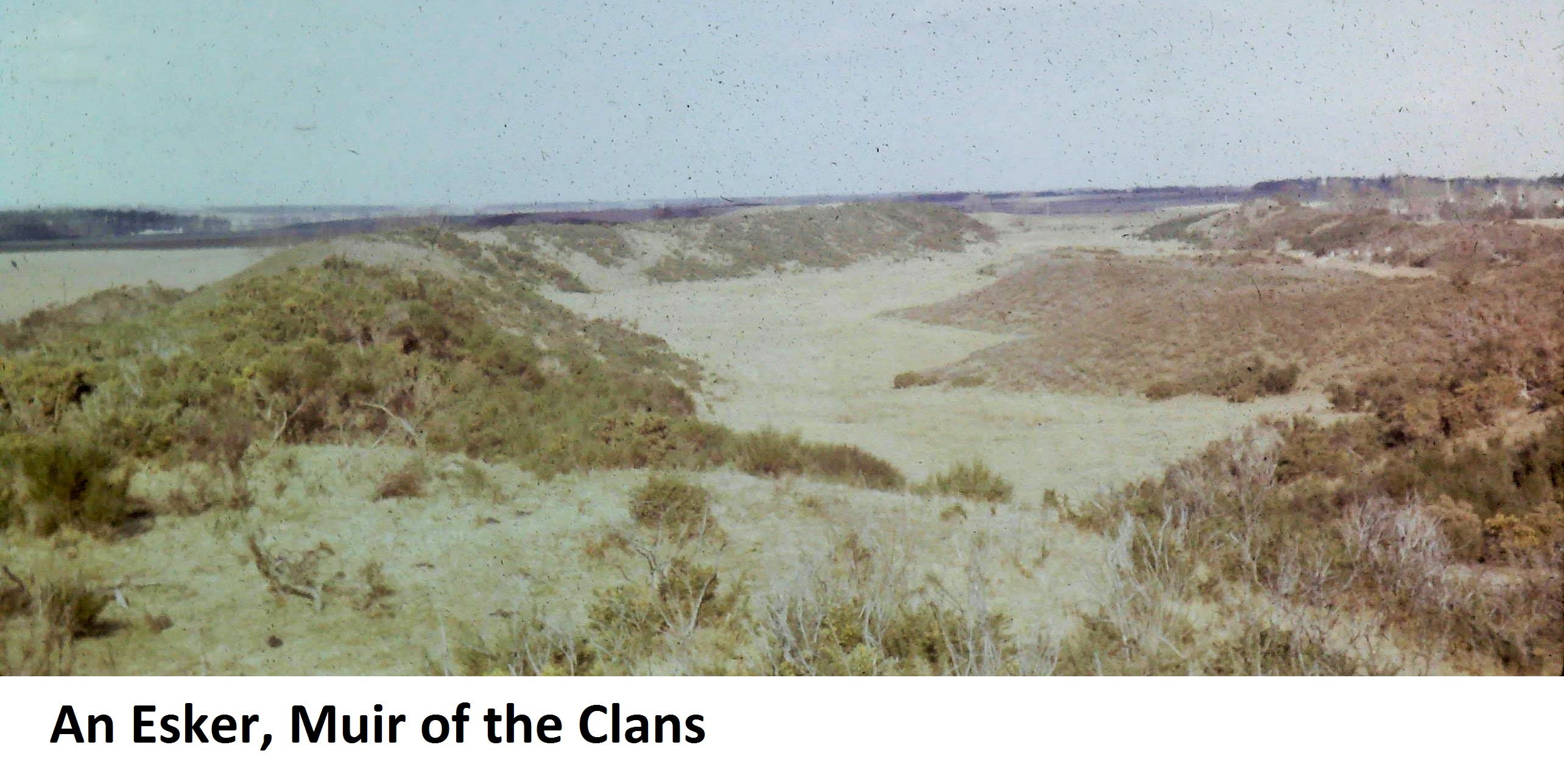
Eskers
Eskers are low, narrow, sinuous ridges made of sorted coarse sand and gravel. They are interpreted as sediment-filled channels from subglacial meltwater streams:
the stream flows under the glacier
sediments accumulate within the channel
when ice retreats, the former channel remains as a ridge
This makes eskers like geological “footprints” of underground flowing water.
Other meltwater-related features
Kames
Kames are mounds of sorted sand and gravel formed when meltwater pushes debris into spaces such as:
crevasses within stagnant ice
As the ice eventually melts away, those sorted deposits collapse into uneven mounds on the ground.
Kame terraces
Kame terraces are similar in that they are also sorted deposits, but they form where meltwater flows along the margin between the ice and valley wall—creating more linear features.
You also correctly distinguish them from lateral moraine:
terraces are sorted (water-laid)
moraines are typically unsorted (ice-laid)
Kettleholes and kettle lakes
A kettlehole forms when a block of ice detaches from the main glacier and becomes buried in meltwater deposits. When that ice block melts, it leaves an enclosed hollow that may fill with water to become a kettlehole lake.
This is a good example of how deposition and melting combine to create a landform—even without continued flowing erosion.
“Kame and kettle” topography
Because kames and kettleholes often occur together, the landscape is often described as “kame and kettle” terrain: irregular hummocks punctuated by depressions.
Braided streams
Braided channels form where meltwater streams become overloaded with coarse sediment, clogging sections of the channel and splitting flow into multiple smaller channels. The result looks like a network of interweaving paths—common in highly sediment-rich meltwater systems.
Powerful meltwater erosion and surprising routes
Meltwater can be extremely energetic, especially during rapid melting in warmer months. That energy can allow streams to:
erode valleys as they flow
cut channels deep into older sediment and bedrock
The Bathgate Hills is an example of this, it is especially interesting because it suggests that meltwater didn’t just carve downhill paths—it could flow in ways that appear counterintuitive, including moving uphill and over obstacles under certain conditions (likely related to meltwater pressure and volume).
Wider-scale deposits: loess (wind-blown silt)
Beyond local valley and upland features, there are also large-scale deposition patterns. One of the most fertile is loess—wind-blown silt.
Loess forms when:
glaciers grind and produce fine particles
winds pick up those particles during post-glacial conditions
dust is spread and gradually accumulates in thick blankets
There are major loess regions (northern France, Germany, Poland, and also parts of North America and China). These fine deposits weather into highly productive soils.
Exam-Style Questions
Short answer (knowledge + definitions)
Define drift in the context of glacial deposition.
List the three ways glaciers transport debris (name each and what part of the glacier it moves with).
What is the difference between till (ground moraine) and outwash (fluvioglacial deposits)?
Define an erratic and explain why its rock type is often different from the local bedrock.
Explain what is meant by sorted vs unsorted glacial material.
Explain and compare (reasoning)
Explain why till is often unsorted.
Explain why fluvioglacial deposits are typically sorted into layers.
Compare terminal moraine and lateral moraine: location, orientation, and what each tells you about ice movement.
Explain how a medial moraine forms.
Explain how a drumlin differs from a typical moraine in terms of how it forms (deposition vs shaping).
Diagram / cross-section style questions
Draw and label a simple model showing meltwater deposition:
ice edge (snout),
meltwater streams,
outwash plain,
where gravel/sand is deposited relative to flow strength.
Data interpretation (application)
A drill core from an outwash plain shows fine silts on top of coarse gravels.
a) What does this suggest about meltwater conditions during deposition?
b) Explain using the concept of particle size settling.
A series of varves near a glacier snout shows alternating thick and thin annual layers.
a) What might thick layers indicate?
b) What might thin layers indicate?
c) Explain your reasoning.
Long answer / structured response (8–12 marks)
“Glacial deposition produces complex landscapes.”
Using the idea of multiple ice advances/retreats, explain how this complexity happens. Include examples of at least four depositional landforms (e.g., moraines, drumlins, eskers, kames, kettleholes, outwash plains).
Explain how a glaciated landscape can include both glacial and fluvioglacial landforms.
Your answer must refer to:
transport within/under/on ice,
sorting vs unsorting,
where each deposit forms relative to the glacier.
Higher tier / tricky conceptual questions
Why might some meltwater streams be able to erode their own channels even after ice retreat begins?
Explain how kame terraces can look similar to moraines but are different in sediment sorting and transport processes.
Describe how braided streams form in meltwater systems and link this to sediment load.
Using loess as an example, explain how glaciation can influence fertile soils far from the ice margin.
FREE Physical Geography resources and Questions
Physical Geography Book
If you would like to support my resources scan the QR code below and Buy me a Coffee